When we checked the weather forecast for the Marlborough region, we also checked the weather for the North Island for the days after, as we wanted to do the Tongariro Alpine Crossing in the middle of the island and maybe even a walk around Mount Taranaki on the west coast. When the forecast said there will only be one really sunny day on the North Island for the whole next week, the decision was clear. We would skip Mount Taranaki where there was only rain forecasted and head straight to Mount Tongariro. It is known as the best day walk in New Zealand and on a clear day you can even see Mount Taranaki from the Tongariro summit. So straight really meant getting up before sunrise the very next day, taking the first ferry to Wellington, there only stopping to book our bus from the car park to the starting point of the walk and continuing on to Tongariro National Park. We drove all day and our hope for good weather changed as often as the weather itself that day. We drove through parts of sunshine and then suddenly heavy rain would come down for 1 hour only to stop again and leave a wall of thick clouds behind. By the time we got to our campground it was completely dark, but the sky was clear. It put our hopes up again for a good day, except that it was freezing cold: the temperature that night dropped to -5Вә. Thank god we had our downy sleeping bags with us. The next morning we had to get up before sunrise again to park our car at the end of the walk and catch our bus that would bring us to the starting point of the walk. We would then basically walk back to our car. When we got out of the van the sky was completely cloudless! We were so excited despite the cold. It was still freezing. In fact, the people next to us who slept in a tent actually had ice on their tent! So we started the trip with 3 layers of clothes, but smiling faces due to the clear sky. On the way to the car park the sun rose and was so bright it blinded us. It was getting better every minute! At the car park it turned out that we weren’t the only ones who planned on this one sunny day to do the walk. 3 buses were full with people. That was actually the first time we did a walk with a big crowd in New Zealand. So far, even though we met other travellers at information centres or at common meeting points, we were usually on our own as soon as we started the walk. This one was different, but it didn’t matter anymore when the bus driver dropped us off with the words: „Welcome to Tongariro National Park. You chose the best day we had in a very long time!“ YEAH, we could have screamed!! All the rush and hassle had been worth it. And then we got out of the bus and the first view already blew us away.
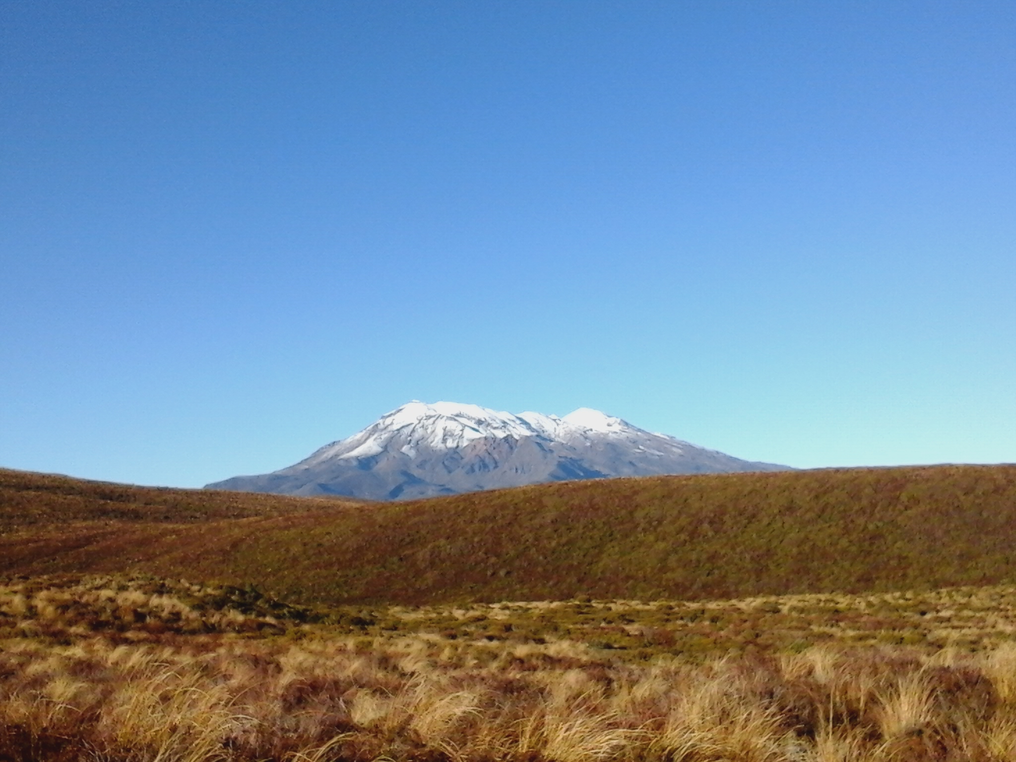
Mount Ruapehu stood proudly to our left and dazzled us with its snow covered top shining in the sun. Little did we know then that every few kilometers a completely different view would surprise us. The standard crossing is a 19.4 kilometer walk. We added 3 kms as we went up to the summit of Mount Tongariro from where you are supposed to have the best view over the country and maybe even see Mount Taranaki on the west coast. So we reckoned we had an 8 hour hike in front of us. Off we went with still 3 layers of long-sleeve clothes on and with probably around other 100 people. Luckily our hiking experience put a gap between us and most of the other group as we speeded up the track in the beginning. The sun was shining brightly now and we had a perfect view of Mount Ngauruhoe, which you can recognise by its red colour and perfect cylindric shape in the pictures. (For all the Lord of the Rings fans, this is Mount Doom.)
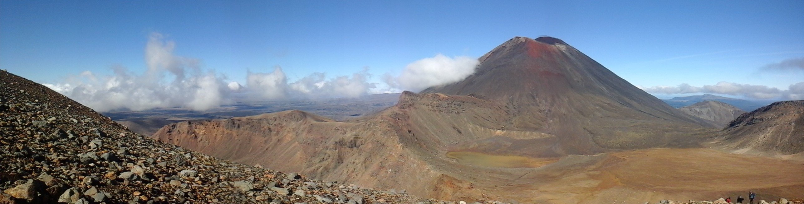
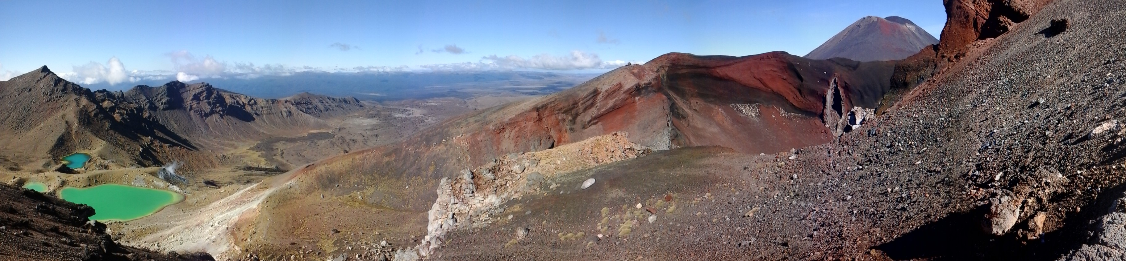
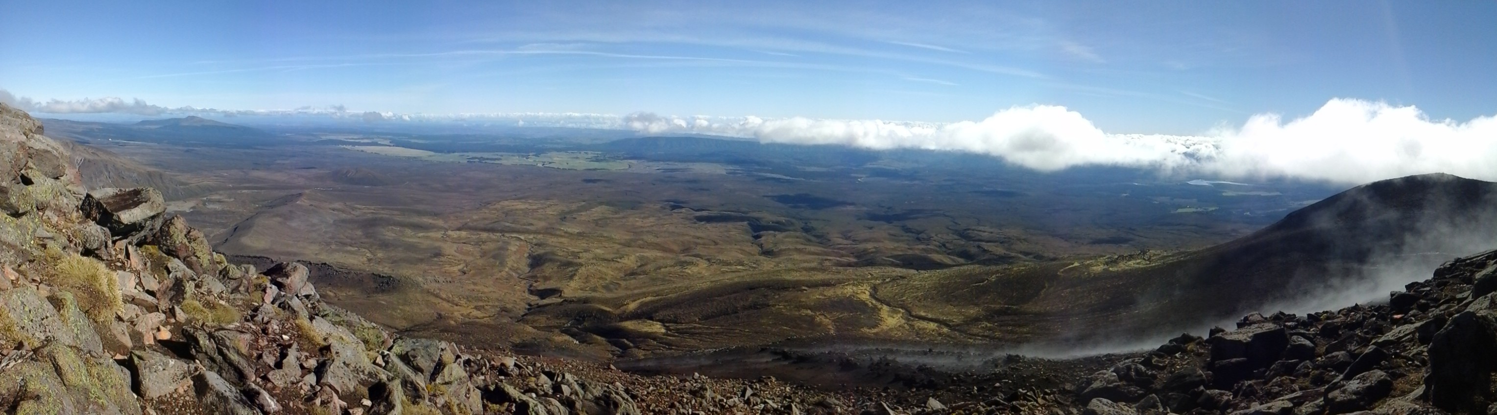
About 30 min into our walk we were down to shorts and t-shirts and had already put sunscreen on. The strangest thing though was that my body seemed to deal with 3 different temperatur zones. My head and upper body were hot from the sun, my hip, upper legs and feet were at normal temperature, but my lower legs were a bit cold due to the cold wind. With long trousers I was too hot though. That phenonemon would continue throughout the whole day as the weather changed with the height from warm and windy to cold and icy winds to then warm again as we walked downhill. I think I changed my clothes about 5 times that day :). The first part of the track took us through a valley full of low alpine plants and bushes, climbing over a succession of lava flows from Mount Ngauruhoe to our right. With every step the sunlight changed Ngauruhoe’s colour from brown to dark and even bright red. Having discovered the panorama function on our tablet a few days before, I could not stop taking pictures every few minutes. When I took them, I thought that a lot of them will probably look alike, but when I viewed them in the evening again I discovered that every picture actually portraits a different colour combination and scenery. Not surprisingly, you will find a lot of panorama pictures in the Tongariro gallery :). The end of the first part brought us to the top of the South Crater which is 1660 metres high. It already became very windy up there and as we continued on to the Tongariro summit, which is 1961 high, the wind turned ice cold despite the shining sun. The ascent was quite steep and some parts of the ground were still covered with thin ice which made it quite slippery. These weather conditions however also created an almost mystic atmosphere, as the heat of the sun turned the ice on the volcanic gravel directly into gas. Steam was coming of the ground all around us and turned it into a magical scenery. We are about to reach the top of Mount Tongariro when the summit is suddenly covered in clouds. Oh, what a disappoinment. All this way to get a great view and then this. Should we even walk up to the end if we can’t see anything? Mathias motivated me to keep going as surely the clouds would go away after some minutes. So we did. We reached the top still covered in clouds, but just a few minutes later the clouds really started to move on and a stunning view over the valley opened up to us. We could even see as far as Mount Taranaki on the west coast. It was so impressive!
We could not get enough of it and decided it was the best place to have our lunch. After a 20 minute lunch, we started down again to continue the other half of the track. To be honest, at that point we thought we had seen the best parts already, but we were wrong again. As we walked down the crater it was incredible to feel the hot ground of the still active crater underneath us. And around the next corner was yet another different view of Mount Ngauruhoe shining in gold and red colours to the right and looking onto the Emerald Lakes on the left. You could now also see where the volcano erupted and left a massive crack that Mathias lovingly called „The big V…“. I think you know what we mean, when you see the picture :).

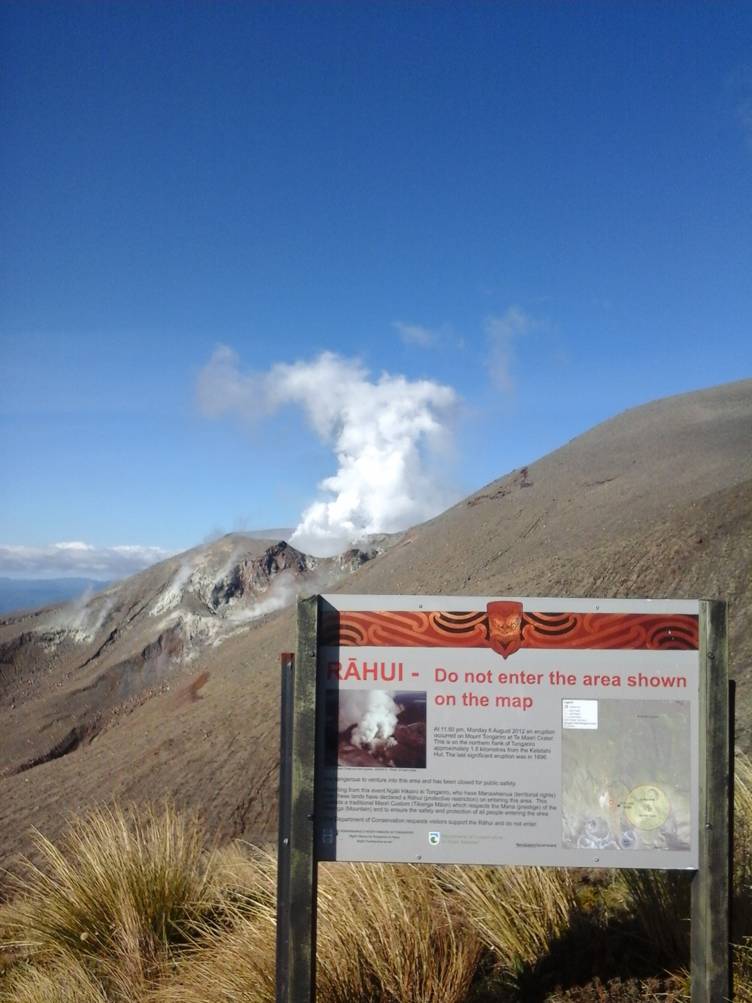
From the Emerald Lakes we walked on to the Blue Lake that glittered in the sunshine and just looked so tranquil in the middle of this volcanic landscape. The picture of Mathias standing in front of it simply is for me the picture perfect. After that there were 2 hours left to walk and the leaflet didn’t say very much apart from a nice walk through the Rotopaunga valley along alpine bushes and flowers. We were thus a bit surprised to suddenly stand in front of sign saying: You are entering the active volcanic hazard zone. And indeed a few meteres later you could smell and see the active volcano Rahui. Quite a bit of smoke was coming of it. How exciting!
The rest of the walk was then about an hour down the valley and again had a complete change in scenery when we suddenly walked through a dense beech forest. We arrived at the car park 7 1/2 hours after we started and were still mesmerized by what we had seen. This was indeed the most spectacular tour in New Zealand. Even now, days later as I am writing this post and looking at the pictures over and over again, I am so impressed. And how lucky we have been with the weather! The next day was all misty and rainy again and as we left Tongariro National Park, not a single volcano was visible. Was it all a dream?
Heeeee, ihr seid ja immer noch so weit weg;-) euch Вҙn schГ¶nen 1.Mai…